1992 Map of Houston
USGS Topo · Published 1992About this map
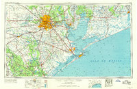
Buffalo Bayou serves as the central artery for this early 1990s depiction of the Gulf Coast's most sprawling metropolitan area. The map illustrates the massive scale of Houston's mid-century expansion, constrained by the flood control infrastructure of Addicks Dam and Barker Reservoir to the west. To the southeast, the industrial corridor along the San Jacinto River connects Pasadena and Deer Park to the complex waterways of Galveston Bay. Academic and scientific hubs are prominent, including Rice University and the NASA Lyndon B Johnson Space Center near Clear Lake. This survey captures the region's energy foundations, documenting the Humble Oil Field and Katy Oil and Gas Field alongside the dense network of the Houston Belt And Terminal railroad and major interstate arteries that defined Texas commerce at the close of the twentieth century.
Find a feature on this map
213 named features on this map. Tap any name to fly to it.
Don’t see what you’re looking for? This feature index may not catch every label — zoom into the map to look around manually.
Map Details
Editions of this 1992 Houston Map
This is the sole edition of this map. No revisions or reprints were ever made.
Historical Maps of Houston Through Time
4 maps found