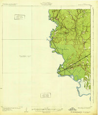
1932 Map of Beaumont
USGS Topo · Published 1932About this map
The Neches River snakes along the western edge of this 1932 survey, marking the jurisdictional boundaries of Jefferson, Hardin, and Orange counties. This preliminary edition highlights a landscape defined by its wetlands and intricate water systems, notably the Beaumont Emergency Water Canal cutting through the lowlands east of the river. The presence of this canal reflects early 20th-century hydraulic engineering efforts to secure water resources for the growing industrial hub of Beaumont.
Find a feature on this map
23 named features on this map. Tap any name to fly to it.
Don’t see what you’re looking for? This feature index may not catch every label — zoom into the map to look around manually.
Map Details
Editions of this 1932 Beaumont Map
2 editions found
Other maps of this area

1926 · Terry
USGS Topo · 1:24,000

1926 · Lakeview
USGS Topo · 1:24,000

1926 · Vidor
USGS Topo · 1:24,000

1926 · Texla
USGS Topo · 1:24,000

1932 · Beaumont
USGS Topo · 1:62,500

1943 · Port Arthur North
USGS Topo · 1:24,000

1943 · Terry
USGS Topo · 1:24,000

1943 · Texla
USGS Topo · 1:24,000

1943 · Fannett East
USGS Topo · 1:24,000

1943 · Beaumont East
USGS Topo · 1:24,000