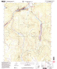
2001 Map of Beaver Creek Reservoir
USGS Topo · Published 2005About this map
The Rio Grande National Forest dominates this high-altitude landscape, where the South Fork Rio Grande and the main Rio Grande carve through the high country of the San Juan Mountains. The 2001 revision highlights the essential water management and recreation infrastructure of the region, anchored by the Beaver Creek Reservoir and the smaller Milton Reservoir. Named peaks such as Goodrich Peak, Grouse Mountain, and Demijohn Peak frame a series of high mesas, including Ribbon Mesa and Handerchief Mesa. This survey reflects the dual identity of the land as both a protected wilderness and a managed resource, shown through the network of forest roads and trails like the Tewksberry Trail. Local activity centers on sites like the Beaver Creek Youth Camp and the small settlement at Goodrich Park, while the presence of Coal Mine Park Creek and Lost Mine Park Cr points to the historical extraction efforts that once occurred alongside the grazing land at Corral Park Creek.
Find a feature on this map
38 named features on this map. Tap any name to fly to it.
Don’t see what you’re looking for? This feature index may not catch every label — zoom into the map to look around manually.
Map Details
Editions of this 2001 Beaver Creek Reservoir Map
This is the sole edition of this map. No revisions or reprints were ever made.
Other maps of this area

1913 · Summitville
USGS Topo · 1:125,000

1914 · Creede
USGS Topo · 1:125,000

1915 · Summitville
USGS Topo · 1:125,000

1916 · Creede
USGS Topo · 1:125,000

1945 · Durango
USGS Topo · 1:250,000

1953 · Durango
USGS Topo · 1:250,000

1954 · Durango
USGS Topo · 1:250,000

1957 · Wolf Creek Pass
USGS Topo · 1:62,500

1957 · Spar City
USGS Topo · 1:62,500

1961 · Durango
USGS Topo · 1:250,000