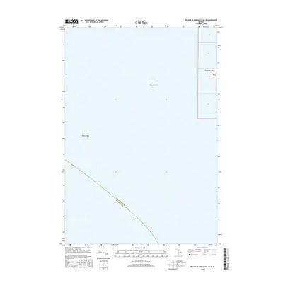
2017 Map of Beaver Island South OE W
USGS Topo · Published 2017About this map
Lake Michigan dominates this maritime survey, illustrating the vast aquatic expanse surrounding the western fringes of the archipelago in Charlevoix County. The map provides a critical navigational perspective on the approach to the southwestern shoreline of Beaver Island, where the land barely enters the eastern margin of the sheet. This area is defined by its underwater geography, most notably Richards Reef, a significant submerged feature that speaks to the hazards and hidden terrain of the Great Lakes. The inclusion of the county boundary between Charlevoix and Leelanau counties, plotted across the open water, highlights the invisible administrative lines that divide these northern waters even miles from the mainland.
Find a feature on this map
9 named features on this map. Tap any name to fly to it.
Don’t see what you’re looking for? This feature index may not catch every label — zoom into the map to look around manually.
Map Details
Editions of this 2017 Beaver Island South OE W Map
This is the sole edition of this map. No revisions or reprints were ever made.
Other maps of this area

1955 · Gull Island
USGS Topo · 1:62,500

1955 · Cheboygan
USGS Topo · 1:250,000

1956 · South Fox Island
USGS Topo · 1:62,500

1956 · Beaver Island
USGS Topo · 1:62,500

1958 · Cheboygan
USGS Topo · 1:250,000

1984 · Beaver Island
USGS Topo · 1:100,000

1984 · Charlevoix
USGS Topo · 1:100,000

1986 · High Island
USGS Topo · 1:24,000
1986 · Gull Island
USGS Topo · 1:24,000
1986 · South Fox Island
USGS Topo · 1:24,000