
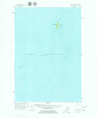
1955 Map of Gull Island
USGS Topo · Published 1959About this map
Gull Island rises from the northern reaches of Lake Michigan in this mid-century hydrographic and topographic study. Located within the administrative boundaries of St James Twp, the island's interior is marked by its highest point, South Gull, and a navigational Light situated on its northern end. The map meticulously details the underwater hazards surrounding this remote landmass, documenting the expansive Gull Island Reef to the southeast and the isolated Boulder Reef to the southwest. These depth soundings and contour intervals reflect the primary data used by mariners navigating the Beaver Island archipelago during the 1950s. The isolation of these landforms illustrates the maritime character of Charlevoix County before modern GPS, where terrestrial landmarks and accurately charted reefs were essential for safe passage through the Great Lakes.
Find a feature on this map
8 named features on this map. Tap any name to fly to it.
Don’t see what you’re looking for? This feature index may not catch every label — zoom into the map to look around manually.
Map Details
Editions of this 1955 Gull Island Map
2 editions found
Other maps of this area

1954 · Escanaba
USGS Topo · 1:250,000

1955 · Cheboygan
USGS Topo · 1:250,000

1956 · South Fox Island
USGS Topo · 1:62,500

1956 · Beaver Island
USGS Topo · 1:62,500

1957 · Escanaba
USGS Topo · 1:250,000

1958 · Escanaba
USGS Topo · 1:250,000

1958 · Cheboygan
USGS Topo · 1:250,000

1983 · Manistique
USGS Topo · 1:100,000

1984 · Washington Island
USGS Topo · 1:100,000

1984 · Beaver Island
USGS Topo · 1:100,000