
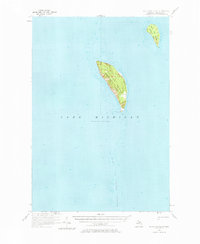
1956 Map of South Fox Island
USGS Topo · Published 1959About this map
The remote archipelago within Leelanau Twp is meticulously detailed in this mid-century survey, focusing on the isolated geography of North Fox Island and South Fox Island. Situated in the deep waters of Lake Michigan, these islands served as vital navigation points for Great Lakes maritime traffic. The presence of the South Fox Island Lighthouse on the southern tip of the larger island highlights the area's importance to shipping safety, while a nearby Landing Field suggests the growing role of aviation in maintaining connections to the mainland by the mid-1950s. The hydrographic data extends far south, charting the submerged hazards of the South Fox Island Shoals, which stretch several miles into the open lake from the primary landmasses.
Find a feature on this map
7 named features on this map. Tap any name to fly to it.
Don’t see what you’re looking for? This feature index may not catch every label — zoom into the map to look around manually.
Map Details
Editions of this 1956 South Fox Island Map
2 editions found
Other maps of this area

1954 · Escanaba
USGS Topo · 1:250,000

1955 · Gull Island
USGS Topo · 1:62,500

1955 · Cheboygan
USGS Topo · 1:250,000

1956 · North Manitou
USGS Topo · 1:62,500

1956 · Beaver Island
USGS Topo · 1:62,500

1957 · Escanaba
USGS Topo · 1:250,000

1957 · Northport
USGS Topo · 1:62,500

1958 · Escanaba
USGS Topo · 1:250,000

1958 · Cheboygan
USGS Topo · 1:250,000

1983 · Manistique
USGS Topo · 1:100,000