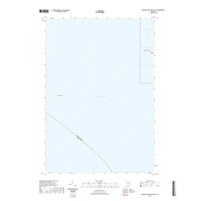
2019 Map of Beaver Island South OE W
USGS Topo · Published 2019About this map
Lake Michigan dominates this coastal survey, where the open waters meet the western edge of Beaver Island. This specific offshore perspective provides a clear view of the underwater topography and maritime hazards, most notably Richards Reef, situated well west of the island's shoreline. The map documents the aquatic border between Charlevoix County and Leelanau County, which runs diagonally through the lake. For those studying the geography of the northern archipelago, the map also identifies the land boundaries of Township 37 North, Range 11 West as it intersects the westernmost fringe of the island.
Find a feature on this map
5 named features on this map. Tap any name to fly to it.
Don’t see what you’re looking for? This feature index may not catch every label — zoom into the map to look around manually.
Map Details
Editions of this 2019 Beaver Island South OE W Map
This is the sole edition of this map. No revisions or reprints were ever made.
Other maps of this area

1955 · Gull Island
USGS Topo · 1:62,500

1955 · Cheboygan
USGS Topo · 1:250,000

1956 · South Fox Island
USGS Topo · 1:62,500

1956 · Beaver Island
USGS Topo · 1:62,500

1958 · Cheboygan
USGS Topo · 1:250,000

1984 · Beaver Island
USGS Topo · 1:100,000

1984 · Charlevoix
USGS Topo · 1:100,000

1986 · High Island
USGS Topo · 1:24,000
1986 · Gull Island
USGS Topo · 1:24,000
1986 · South Fox Island
USGS Topo · 1:24,000