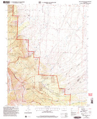
2001 Map of Beck Mountain
USGS Topo · Published 2005About this map
High peaks and remote ranching infrastructure define this section of the Southern Rockies at the turn of the 21st century. The map centers on the high-altitude transition from the Wet Mountain Valley to the dramatic crest of the Sangre De Cristo Wilderness, where jagged summits like Blizzardine Peak and Snowslide Mountain overlook the Great Sand Dunes National Preserve. Human presence is marked by isolated outposts and early industrial attempts, such as the Henrich Ranch in the north and the Bear Creek Prospect near Crystal Falls. The land-use patterns here reflect a mix of preservation and legacy agriculture, with the San Carlos Ranger District managing vast tracts of forest while cattle operations rely on features like the Doc Watkins Windmill and Wolf Windmill in the lower gulches.
Find a feature on this map
42 named features on this map. Tap any name to fly to it.
Don’t see what you’re looking for? This feature index may not catch every label — zoom into the map to look around manually.
Map Details
Editions of this 2001 Beck Mountain Map
This is the sole edition of this map. No revisions or reprints were ever made.
Other maps of this area

1889 · Canon City
USGS Topo · 1:125,000

1889 · Huerfano Park
USGS Topo · 1:125,000

1892 · Huerfano Park
USGS Topo · 1:125,000

1892 · Canon City
USGS Topo · 1:125,000

1954 · Rosita
USGS Topo · 1:24,000

1954 · Trinidad
USGS Topo · 1:250,000

1954 · Pueblo
USGS Topo · 1:250,000

1955 · Trinidad
USGS Topo · 1:250,000

1957 · Pueblo
USGS Topo · 1:250,000

1957 · Aldrich Gulch
USGS Topo · 1:24,000