1978 Map of Beckman Lake
USGS Topo · Published 1978About this map
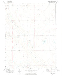
Beckman Lake (Alkali) and the converging forks of the Rush Creek drainage system define the sparse, arid landscape of this Lincoln County region during the late 1970s. The terrain is characterized by a network of seasonal water sources, including North Rush Creek, Middle Rush Creek, and South Rush Creek, which wind through the plains. The presence of numerous Wells, tanks, and isolated Springs highlights the critical importance of water management for ranching and agricultural survival in this high plains environment. Surveyed by the U.S. Geological Survey using photogrammetric methods, the map documents a territory where human activity is largely represented by scattered infrastructure and section-line roads, revealing the quiet, functional nature of the Colorado prairie before any modern suburban expansion.
Find a feature on this map
6 named features on this map. Tap any name to fly to it.
Don’t see what you’re looking for? This feature index may not catch every label — zoom into the map to look around manually.
Map Details
Editions of this 1978 Beckman Lake Map
This is the sole edition of this map. No revisions or reprints were ever made.
Other maps of this area

1889 · Sanborn
USGS Topo · 1:125,000

1891 · Sanborn
USGS Topo · 1:125,000

1891 · Arroyo
USGS Topo · 1:125,000

1891 · Limon
USGS Topo · 1:125,000

1892 · Limon
USGS Topo · 1:125,000
1893 · Arroyo
USGS Topo · 1:125,000

1893 · Sanborn
USGS Topo · 1:125,000

1954 · Limon
USGS Topo · 1:250,000

1954 · Lamar
USGS Topo · 1:250,000

1957 · Limon
USGS Topo · 1:250,000