Loading...
Loading map...1934 Map of Bedford
USGS Topo · Published 1958About this map
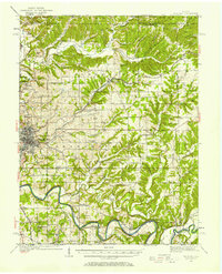
The limestone industry of southern Indiana is on full display here, as Fanning Quarry, Peerless Quarry, and Lehigh Quarry surround the city of Bedford. This 1934 survey reflects a period when the regional economy was heavily defined by both these stone operations and an extensive railroad network, including the Milwaukee St Paul and Pacific and the Chicago Indianapolis and Louisville.
Find a feature on this map
78 named features on this map. Tap any name to fly to it.
Don’t see what you’re looking for? This feature index may not catch every label — zoom into the map to look around manually.
Map Details
Date Portrayed1934
Date Published1958
PublisherU.S. Geological Survey
Map TypeTopographic
Scale1:62,500
Physical Dimensions17 x 21 inches
Editions of this 1934 Bedford Map
2 editions found
Historical Maps of Bedford Through Time
4 maps found


Featured Locations
Source Details
SourceU.S. Geological Survey
CopyrightPublic Domain