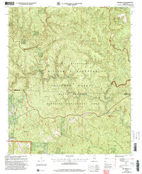
2000 Map of Bee Branch
USGS Topo · Published 2003About this map
William B Bankhead National Forest dominates this landscape at the boundary of Lawrence and Winston counties, reflecting a wilderness-management era defined by the Sipsey Wilderness and the Black Warrior Wildlife Management Area. The terrain is carved by the Sipsey Fork and its numerous tributaries, including Thompson Creek and Flannagin Creek. While the interior is largely undeveloped forest, small-scale settlement patterns are evident on the periphery, particularly around Rabbitown and Shiloh Ch in the southwest. For genealogists and local historians, the map preserves the locations of several family-named burial grounds, such as Wolfpen Cem, Hunter Cem, and Johnson Cem, which provide clues to the early homesteads that predated the federal forest designation. High points like Bunyan Hill and Balls Mountain overlook a network of hollows that once sheltered these rural communities.
Find a feature on this map
31 named features on this map. Tap any name to fly to it.
Don’t see what you’re looking for? This feature index may not catch every label — zoom into the map to look around manually.
Map Details
Editions of this 2000 Bee Branch Map
This is the sole edition of this map. No revisions or reprints were ever made.
Other maps of this area

1935 · Moulton
USGS Topo · 1:24,000

1936 · Newburg
USGS Topo · 1:24,000

1936 · Delmar
USGS Topo · 1:24,000

1936 · Kinlock Spring
USGS Topo · 1:24,000

1936 · Moulton
USGS Topo · 1:48,000

1936 · Landersville
USGS Topo · 1:24,000

1940 · Mt Hope
USGS Topo · 1:62,500
1945 · Newburg
USGS Topo · 1:24,000
1947 · Newburg
USGS Topo · 1:24,000

1947 · Kinlock Spring
USGS Topo · 1:24,000