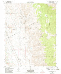
1982 Map of Bee Springs Canyon
USGS Topo · Published 1983About this map
Mining operations and rugged desert drainage systems define this section of the Inyo Mountains during the early 1980s. The landscape is marked by numerous historical extraction sites, ranging from the Old Whiteside Diggings and Copper Queen Mine in the north to the Reward Mine at the southern edge. The distribution of these mines along the western slopes of the range suggests a specific geological corridor sought by prospectors, accessed by the winding Mazourka Canyon Road. Within the Inyo National Forest, several springs provide rare water sources in an otherwise arid environment, including Bee Spring and Coyote Spring. The inclusion of the Winnedumah Paiute Monument on the high ridges highlights a significant cultural and geographic landmark overlooking the steep descents of Willow Springs Gulch and Vaughn Gulch. Water infrastructure is represented by the Mc Iver Canal, tracing the lower elevations where the mountains meet the valley floor.
Find a feature on this map
30 named features on this map. Tap any name to fly to it.
Don’t see what you’re looking for? This feature index may not catch every label — zoom into the map to look around manually.
Map Details
Editions of this 1982 Bee Springs Canyon Map
This is the sole edition of this map. No revisions or reprints were ever made.
Other maps of this area

1907 · Mt. Whitney
USGS Topo · 1:125,000

1908 · Ballarat
USGS Topo · 1:250,000

1913 · Ballarat
USGS Topo · 1:250,000

1919 · Mt. Whitney
USGS Topo · 1:125,000

1937 · Mt. Whitney
USGS Topo · 1:125,000

1948 · Death Valley
USGS Topo · 1:250,000

1948 · Fresno
USGS Topo · 1:250,000

1950 · New York Butte
USGS Topo · 1:62,500

1951 · New York Butte
USGS Topo · 1:62,500

1951 · Waucoba Wash
USGS Topo · 1:62,500