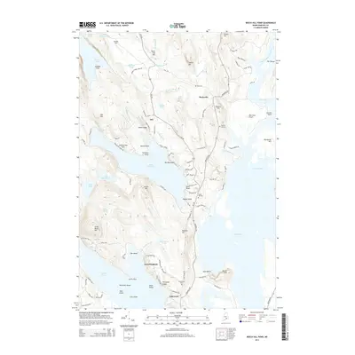
2014 Map of Beech Hill Pond
USGS Topo · Published 2014About this map
Beech Hill Pond and the expansive waters of Graham Lake dominate this landscape within the Ellsworth city limits and neighboring townships. The area is defined by its complex glacial topography, where numerous smaller water bodies like Floods Pond, Wormwood Pond, and Youngs Pond are scattered among named elevations such as Tannery Hill and Grotto Hill. Settlement patterns follow the winding routes of Mariaville Rd and Otis Rd, connecting small communities like Mariaville and Otis. The Union River and its West Branch Union River flow through the eastern portion of the map, carving through terrain that includes distinctive landmarks like Junk of Pork Rock. Local heritage is preserved in several small burial sites, including Pyles Cem and Greenwood Cem, which are situated near established residential pockets like Lakewood.
Find a feature on this map
112 named features on this map. Tap any name to fly to it.
Don’t see what you’re looking for? This feature index may not catch every label — zoom into the map to look around manually.
Map Details
Editions of this 2014 Beech Hill Pond Map
This is the sole edition of this map. No revisions or reprints were ever made.
Other maps of this area

1900 · Orland
USGS Topo · 1:62,500

1902 · Orono
USGS Topo · 1:62,500

1911 · Ellsworth
USGS Topo · 1:62,500

1929 · Great Pond
USGS Topo · 1:48,000

1932 · Great Pond
USGS Topo · 1:62,500

1940 · Ellsworth
USGS Topo · 1:62,500

1942 · Orland
USGS Topo · 1:62,500

1942 · Ellsworth
USGS Topo · 1:62,500

1944 · Orono
USGS Topo · 1:62,500

1946 · Orono
USGS Topo · 1:62,500