1942 Map of Ellsworth
USGS Topo · Published 1942About this map
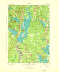
The Union River corridor and its surrounding coastal lowlands define this early 1940s landscape, centered on the growing hub of Ellsworth. The Maine Central railroad is a vital artery here, passing through Washington Junction and Franklin Road as it connects the inland settlements to the sea. To the east, the rural character of No 8 Plantation is preserved through landmarks like the No 8 Plantation Sch, while the coast is deeply indented by tidal waters such as Partridge Cove and the Skillings River. The map captures a moment when small post offices like North Hancock P O and tiny communities like Bloxton served as the social centers for a region defined by its water power and rail access, anchored by the Brimmer Dam and the industrial activity at Ellsworth Falls.
Find a feature on this map
88 named features on this map. Tap any name to fly to it.
Don’t see what you’re looking for? This feature index may not catch every label — zoom into the map to look around manually.
Map Details
Editions of this 1942 Ellsworth Map
This is the sole edition of this map. No revisions or reprints were ever made.
Other maps of this area

1900 · Orland
USGS Topo · 1:62,500

1902 · Orono
USGS Topo · 1:62,500

1904 · Mount Desert
USGS Topo · 1:62,500

1904 · Bar Harbor
USGS Topo · 1:62,500

1904 · Bluehill
USGS Topo · 1:62,500

1905 · Penobscot Bay
USGS Topo · 1:125,000

1911 · Ellsworth
USGS Topo · 1:62,500

1929 · Great Pond
USGS Topo · 1:48,000

1929 · Lead Mountain
USGS Topo · 1:48,000

1930 · Tunk Lake
USGS Topo · 1:48,000