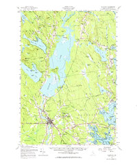
1957 Map of Ellsworth
USGS Topo · Published 1971About this map
Ellsworth and its surroundings serve as a vital coastal hub in the mid-1950s, centered on the confluence of rail and river commerce. The Maine Central Railroad creates a significant infrastructure network through Washington Junction and up toward West Franklin, while the Union River remains the landscape's industrial backbone. The presence of Graham Dam and the settlement at Ellsworth Falls illustrate the historical reliance on water power and river management.
Find a feature on this map
131 named features on this map. Tap any name to fly to it.
Don’t see what you’re looking for? This feature index may not catch every label — zoom into the map to look around manually.
Map Details
Editions of this 1957 Ellsworth Map
3 editions found
Other maps of this area

1900 · Orland
USGS Topo · 1:62,500

1902 · Orono
USGS Topo · 1:62,500

1904 · Mount Desert
USGS Topo · 1:62,500

1904 · Bar Harbor
USGS Topo · 1:62,500

1904 · Bluehill
USGS Topo · 1:62,500

1905 · Penobscot Bay
USGS Topo · 1:125,000

1911 · Ellsworth
USGS Topo · 1:62,500

1929 · Great Pond
USGS Topo · 1:48,000

1929 · Lead Mountain
USGS Topo · 1:48,000

1930 · Tunk Lake
USGS Topo · 1:48,000