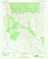
1967 Map of Beecher Canyon
USGS Topo · Published 1969About this map
The San Francisco Mine sits at the northern edge of the Hualapai Mountains, anchoring a landscape of steep canyons and cattle ranching infrastructure in the late 1960s. This territory transitions from the high peaks of the range down into the broad expanse of Dutch Flat to the southwest. The distribution of water sources, including Beecher Spring, Pipeline Spring, and Ox Yoke Spring, reveals the critical network required for high-desert survival and industry. Ranching heritage is evidenced by family-named landmarks and functional improvements such as Daryls Well, Old Ranch Well, and the Crozier Tank. Transport through this arid terrain relied on the Alamo Road and a series of rugged jeep trails and footpaths like the Trail near Gilroy Canyon, tracing the natural paths carved by Beecher Canyon and Crozier Wash.
Find a feature on this map
27 named features on this map. Tap any name to fly to it.
Don’t see what you’re looking for? This feature index may not catch every label — zoom into the map to look around manually.
Map Details
Editions of this 1967 Beecher Canyon Map
This is the sole edition of this map. No revisions or reprints were ever made.
Other maps of this area

1923 · Signal
USGS Topo · 1:250,000

1942 · Signal
USGS Topo · 1:250,000

1950 · Prescott
USGS Topo · 1:250,000

1954 · Prescott
USGS Topo · 1:250,000

1958 · Prescott
USGS Topo · 1:250,000

1959 · Prescott
USGS Topo · 1:250,000

1960 · Prescott
USGS Topo · 1:250,000

1965 · Prescott
USGS Topo · 1:250,000
1967 · Groom Spring
USGS Topo · 1:24,000
1967 · Dutch Flat SE
USGS Topo · 1:24,000