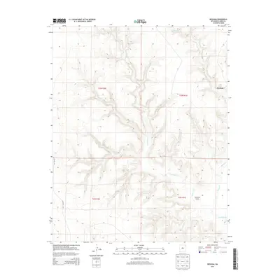
2013 Map of Beenham
USGS Topo · Published 2013About this map
Tramperos Canyon dominates the southern half of this Union County landscape, where the deeply carved drainage of Tramperos Cr meets the high plains of northeastern New Mexico. This 2013 survey documents a remote corner of the state where the small settlement of Beenham sits near the edge of the canyon system. The mapping detail highlights the dramatic topographical transition from the flat tablelands to the complex breaks and draws of the canyon floor. Surface transport is limited to a few local routes, including CO Highway C-015, which skirts the western edge of the quadrangle. The hydrology of the area is defined by seasonal waterways like Bushnell Cr, illustrating the rugged erosional patterns characteristic of this high-altitude ranching country.
Find a feature on this map
9 named features on this map. Tap any name to fly to it.
Don’t see what you’re looking for? This feature index may not catch every label — zoom into the map to look around manually.
Map Details
Editions of this 2013 Beenham Map
This is the sole edition of this map. No revisions or reprints were ever made.
Other maps of this area

1954 · Dalhart
USGS Topo · 1:250,000

1958 · Dalhart
USGS Topo · 1:250,000

1962 · Dalhart
USGS Topo · 1:250,000

1973 · Yates SE
USGS Topo · 1:24,000

1973 · Garcia Creek
USGS Topo · 1:24,000

1973 · Beenham
USGS Topo · 1:24,000
1973 · Minnie Butte
USGS Topo · 1:24,000

1973 · Romero Spring
USGS Topo · 1:24,000
1973 · Goat Canyon
USGS Topo · 1:24,000
1973 · Pennington
USGS Topo · 1:24,000