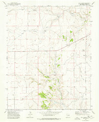
1973 Map of Goat Canyon
USGS Topo · Published 1978About this map
Sanchez Cem and La Moreda Cem are prominent markers of family heritage in this section of Union County, mapped during the early 1970s. The landscape is defined by a series of deep drainage systems, most notably Goat Canyon and Chavez Canyon, which channel water toward the larger creek networks. The importance of water management in this arid region is evident through the naming of specific livestock and residential water sources such as Morrow Windmill, Antelope Well, and Middle Well. While the settlement of Daves sits near the eastern edge, much of the area is traversed by a Jeep Trail, reflecting a rugged environment where transportation remained tied to natural topography. These features, along with Jarosito Canyon and Leal Canyon, illustrate the dispersed settlement patterns and the essential reliance on seasonal water like Pinabetes Creek.
Find a feature on this map
19 named features on this map. Tap any name to fly to it.
Don’t see what you’re looking for? This feature index may not catch every label — zoom into the map to look around manually.
Map Details
Editions of this 1973 Goat Canyon Map
This is the sole edition of this map. No revisions or reprints were ever made.
Other maps of this area

1954 · Dalhart
USGS Topo · 1:250,000

1958 · Dalhart
USGS Topo · 1:250,000

1962 · Dalhart
USGS Topo · 1:250,000

1966 · Black Canyon
USGS Topo · 1:24,000

1966 · Tate School
USGS Topo · 1:24,000

1966 · Car Top Butte
USGS Topo · 1:24,000

1973 · Snyder Lake
USGS Topo · 1:24,000

1973 · Tripod Mountain
USGS Topo · 1:24,000

1973 · Garcia Creek
USGS Topo · 1:24,000

1973 · Beenham
USGS Topo · 1:24,000