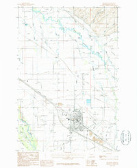
1987 Map of Belgrade
USGS Topo · Published 1988About this map
Belgrade serves as the focal point of this Gallatin County survey, situated at a critical junction of Montana's rail and water infrastructure. The Burlington Northern railroad cuts a diagonal path through the landscape, flanked by numerous Gravel Pits that suggest a region shaped by industrial extraction. To the north and east, a dense network of watercourses including the East Gallatin River, Story Creek, and Foster Creek meander across the plains, reflecting the complex drainage patterns of the Gallatin Valley.
Find a feature on this map
31 named features on this map. Tap any name to fly to it.
Don’t see what you’re looking for? This feature index may not catch every label — zoom into the map to look around manually.
Map Details
Editions of this 1987 Belgrade Map
This is the sole edition of this map. No revisions or reprints were ever made.
Other maps of this area

1888 · Three Forks
USGS Topo · 1:250,000

1894 · Three Forks
USGS Topo · 1:250,000

1895 · Three Forks
USGS Topo · 1:250,000

1947 · Bozeman
USGS Topo · 1:250,000

1948 · Bozeman
USGS Topo · 1:250,000

1949 · Anceney
USGS Topo · 1:62,500

1949 · Manhattan
USGS Topo · 1:62,500

1950 · Belgrade
USGS Topo · 1:62,500

1953 · Bozeman
USGS Topo · 1:62,500

1955 · Bozeman
USGS Topo · 1:250,000