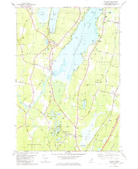
1980 Map of Belgrade
USGS Topo · Published 1980About this map
The central Maine lakeland, as documented in 1980, is defined by the complex aquatic network of Messalonskee Lake and the eastern edge of Great Pond. Settlement patterns here follow the high ground between these waters and the extensive wetlands of Belgrade Bog and Austin Bog. The village of Belgrade sits at a critical junction where the Maine Central railroad corridor meets the southern tip of Great Pond. Genealogy researchers will find a high density of small family and community burial grounds, including the Woodside Cem, Sawtelle Cem, and Quaker Cem on Quaker Hill. The map also details the local infrastructure of the era, from the Belgrade Central School and the WLBZ Radio Tower to the numerous gravel pits that speak to the region's glacial geology and ongoing development.
Find a feature on this map
86 named features on this map. Tap any name to fly to it.
Don’t see what you’re looking for? This feature index may not catch every label — zoom into the map to look around manually.
Map Details
Editions of this 1980 Belgrade Map
2 editions found
Other maps of this area

1892 · Waterville
USGS Topo · 1:62,500

1892 · Augusta
USGS Topo · 1:62,500

1893 · Vassalboro
USGS Topo · 1:62,500

1894 · Norridgewock
USGS Topo · 1:62,500

1898 · Norridgewock
USGS Topo · 1:62,500

1898 · Vassalboro
USGS Topo · 1:62,500

1941 · Vassalboro
USGS Topo · 1:62,500

1941 · Augusta
USGS Topo · 1:62,500

1943 · Augusta
USGS Topo · 1:62,500

1943 · Vassalboro
USGS Topo · 1:62,500