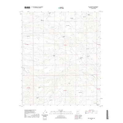
2020 Map of Bell Mountain
USGS Topo · Published 2020About this map
Bell Mtn and the southern reaches of the Salado Mountains dominate this high-desert landscape in Sierra County. The terrain is defined by a network of wide mesas and deep canyons, including Johnson Mesa, Miller Mesa, and Cave Creek Mesa, many of which are named for early ranching families or local landmarks. The distribution of water sources across this arid environment is remarkably dense, with numerous engineered tanks such as East South Salado Peak Tank and West Myers Tank supporting the region's livestock operations. Travel is primarily restricted to corridors like Las Animas Creek Rd and Ladder Ranch Rd, which follow the natural drainage patterns of Las Animas Cr and Seco Cr. The presence of Bodine Spring and Warm Spring highlights the precious natural water points that have historically anchored settlement and movement in this part of New Mexico.
Find a feature on this map
55 named features on this map. Tap any name to fly to it.
Don’t see what you’re looking for? This feature index may not catch every label — zoom into the map to look around manually.
Map Details
Editions of this 2020 Bell Mountain Map
This is the sole edition of this map. No revisions or reprints were ever made.
Other maps of this area

1935 · Hillsboro
USGS Topo · 1:48,000

1940 · Hillsboro
USGS Topo · 1:62,500

1954 · Tularosa
USGS Topo · 1:250,000

1955 · Las Cruces
USGS Topo · 1:250,000

1958 · Las Cruces
USGS Topo · 1:250,000

1958 · Tularosa
USGS Topo · 1:250,000

1961 · Skute Stone Arroyo
USGS Topo · 1:24,000

1961 · Saladone Tank
USGS Topo · 1:24,000

1961 · Williamsburg NW
USGS Topo · 1:24,000

1963 · Bell Mountain
USGS Topo · 1:24,000