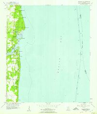
1956 Map of Bellefontaine
USGS Topo · Published 1957About this map
Mon Louis Island dominates this mid-century coastal survey, showing a landscape defined by the winding waters of the Fowl River and the expansive Mobile Bay. Along the western shoreline, small coastal settlements such as Bellefontaine, Sunny Cove, and Mon Louis are connected by the north-south artery of Cedar Point Road. The map reveals a transitional economy where established family names and landmarks like Bayleys Corner and Smithport sit alongside industrial features like the deep-water Mobile Ship Channel. An Old Railroad Grade cutting through the marshlands toward Pt Judith provides evidence of former transport routes no longer in active rail service by the 1950s. The interior is a intricate network of waterways, including Bayou Austin and Bayou Whitehouse, which served as critical drainage and navigation points for the residents of Faustinas and nearby fishing communities.
Find a feature on this map
26 named features on this map. Tap any name to fly to it.
Don’t see what you’re looking for? This feature index may not catch every label — zoom into the map to look around manually.
Map Details
Editions of this 1956 Bellefontaine Map
4 editions found
Other maps of this area

1921 · Point Clear
USGS Topo · 1:62,500

1921 · Fairhope
USGS Topo · 1:62,500

1921 · Delchamps
USGS Topo · 1:62,500

1922 · Mobile
USGS Topo · 1:62,500

1939 · Daphne
USGS Topo · 1:31,680

1940 · Hollingers Island
USGS Topo · 1:31,680

1940 · Mobile
USGS Topo · 1:62,500

1941 · Daphne
USGS Topo · 1:31,680

1941 · Cedar Point
USGS Topo · 1:62,500

1941 · Weeks Bay
USGS Topo · 1:62,500