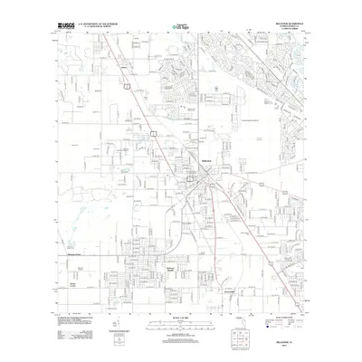
2012 Map of Belleview
USGS Topo · Published 2012About this map
Belleview serves as the central hub of this Marion County corridor, situated between the communities of Santos to the north and Summerfield to the south. The landscape is defined by its numerous small lakes and geological depressions, most notably the prominent Blue Sink and Lake Sparkle. The area's layout shows a transition from the established residential grid of the city to more specialized developments like Belleview Heights and Danks Corner. For those tracing local families, the map provides precise locations for several regional burial grounds, including Burrell Cem, Fisher Cem, and Mount Pisgah Cem. Transportation and recreation are key themes here, evidenced by the presence of Leeward Air Ranch Airport, Norton Airport, and the Panther Lake Golf Course. Educational and civic landmarks like Taylor College and the City of Belleview Water Tower help ground the mid-2010s development of this Central Florida region.
Find a feature on this map
41 named features on this map. Tap any name to fly to it.
Don’t see what you’re looking for? This feature index may not catch every label — zoom into the map to look around manually.
Map Details
Editions of this 2012 Belleview Map
This is the sole edition of this map. No revisions or reprints were ever made.
Other maps of this area

1893 · Panasoffkee
USGS Topo · 1:62,500

1895 · Panasoffkee
USGS Topo · 1:62,500

1895 · Ocala
USGS Topo · 1:62,500

1954 · Gainesville
USGS Topo · 1:250,000

1954 · Daytona Beach
USGS Topo · 1:250,000

1955 · Plant City
USGS Topo · 1:250,000

1955 · Orlando
USGS Topo · 1:250,000

1957 · Orlando
USGS Topo · 1:250,000

1958 · Orlando
USGS Topo · 1:250,000

1958 · Daytona Beach
USGS Topo · 1:250,000