1991 Map of Belleview
USGS Topo · Published 1991About this map
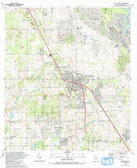
The town of Belleview serves as the central hub of this 1991 survey, situated at the junction of major transit corridors in Marion County. To the north, the growing community of Silver Springs Shores is marked by its residential patterns and golf course, while smaller settlements like Santos and Summerfield define the outlying landscape. This era shows a region transitioning between agricultural roots and suburban development, with numerous active extraction sites such as the Quarry and Sandpit operations scattered throughout the terrain.
Find a feature on this map
61 named features on this map. Tap any name to fly to it.
Don’t see what you’re looking for? This feature index may not catch every label — zoom into the map to look around manually.
Map Details
Editions of this 1991 Belleview Map
This is the sole edition of this map. No revisions or reprints were ever made.
Other maps of this area

1893 · Panasoffkee
USGS Topo · 1:62,500

1895 · Panasoffkee
USGS Topo · 1:62,500

1895 · Ocala
USGS Topo · 1:62,500

1954 · Gainesville
USGS Topo · 1:250,000

1954 · Daytona Beach
USGS Topo · 1:250,000

1955 · Plant City
USGS Topo · 1:250,000

1955 · Orlando
USGS Topo · 1:250,000

1957 · Orlando
USGS Topo · 1:250,000

1958 · Orlando
USGS Topo · 1:250,000

1958 · Daytona Beach
USGS Topo · 1:250,000