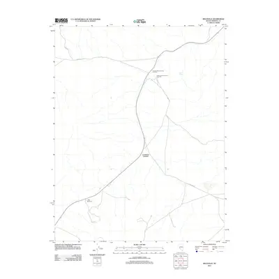
2011 Map of Belleville
USGS Topo · Published 2011About this map
Industrial remains of the mining era dominate this portion of Mineral County, centered on the infrastructure that once supported the silver rush. The map identifies the sites of the Northern Belle Companys Lower Mill and the Northern Belle Companys Upper Mill, marking the heavy processing footprint required to extract wealth from the surrounding desert. The landscape is a network of functional transit points and water sources, including Candelaria Junction and the critical Belleville Spring. Higher elevations like Little Summit overlook a terrain traversed by utilitarian routes such as Moho Rd, Garfield Flat Rd, and Pump Hse Rd. This survey documents a quieted landscape where the placement of mills and junctions still traces the logic of nineteenth-century resource extraction and desert survival.
Find a feature on this map
8 named features on this map. Tap any name to fly to it.
Don’t see what you’re looking for? This feature index may not catch every label — zoom into the map to look around manually.
Map Details
Editions of this 2011 Belleville Map
This is the sole edition of this map. No revisions or reprints were ever made.
Other maps of this area

1909 · Hawthorne
USGS Topo · 1:250,000

1911 · Hawthorne
USGS Topo · 1:250,000

1915 · Hawthorne
USGS Topo · 1:250,000

1948 · Walker Lake
USGS Topo · 1:250,000

1957 · Walker Lake
USGS Topo · 1:250,000

1962 · Walker Lake
USGS Topo · 1:250,000

1964 · Walker Lake
USGS Topo · 1:250,000
1967 · Columbus
USGS Topo · 1:24,000
1967 · Miller Mountain
USGS Topo · 1:24,000

1967 · Moho Mountain
USGS Topo · 1:24,000