
1953 Map of Bellingham
USGS Topo · Published 1955About this map
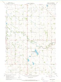
The Minnesota River valley and the diverse hydrography of the Yellow Bank River's north and south forks define this 1950s landscape on the border of South Dakota and Minnesota. Small prairie settlements including Bellingham, Marietta, and Nassau serve as regional hubs, connected by the Great Northern railroad and a grid of rural roads. The area is notable for its high density of local educational and religious institutions, including Immanuel Ch, Zion Ch, and the Swedish Mission Cem. A significant historical landmark is the Old Indian Boundary, which cuts diagonally across the townships, marking an earlier era of territorial division. The terrain is marked by numerous seasonal water bodies like Boehnke Slough and Kaufman Slough, alongside several schoolhouses already marked as abandoned by the time of this survey, such as School No 19 and School No 50.
Find a feature on this map
45 named features on this map. Tap any name to fly to it.
Don’t see what you’re looking for? This feature index may not catch every label — zoom into the map to look around manually.
Map Details
Editions of this 1953 Bellingham Map
This is the sole edition of this map. No revisions or reprints were ever made.
Other maps of this area

1953 · Ortonville
USGS Topo · 1:62,500

1953 · Milbank
USGS Topo · 1:250,000

1953 · Watertown
USGS Topo · 1:250,000

1954 · Big Stone Lake
USGS Topo · 1:62,500

1958 · Milbank
USGS Topo · 1:250,000

1958 · Watertown
USGS Topo · 1:250,000

1958 · Madison
USGS Topo · 1:24,000

1958 · Correll
USGS Topo · 1:24,000

1967 · Gary NW
USGS Topo · 1:24,000
1967 · Dawson NW
USGS Topo · 1:24,000