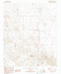
1989 Map of Belmont Mountain
USGS Topo · Published 1990About this map
Belmont Mountains dominate this Maricopa County terrain, revealing a landscape defined by desert mining operations and ephemeral water sources. Prospectors and mining engineers long focused on the mineral wealth found here, leaving behind named sites such as the Tonopah-Belmont Mine and the Belmont Mountain Mine. Smaller operations like the Black Pearl Mine and Morning Star Mine are scattered across the slopes, connected by a network of unimproved roads and trails. The scarcity of permanent water is reflected in the critical importance of wells, including Tiger Well and the curiously named Beer Bottle Well. Natural drainage follows the paths of dry washes such as Woodchopper Wash and Coyote Wash, which cut through the Hassayampa Plain to the northeast. This 1989 provisional update captures the area's transition between historical extraction and modern land management, documenting various tanks and powerline corridors.
Find a feature on this map
21 named features on this map. Tap any name to fly to it.
Don’t see what you’re looking for? This feature index may not catch every label — zoom into the map to look around manually.
Map Details
Editions of this 1989 Belmont Mountain Map
This is the sole edition of this map. No revisions or reprints were ever made.
Other maps of this area

1942 · Vicksburg
USGS Topo · 1:250,000

1954 · Phoenix
USGS Topo · 1:250,000

1957 · Phoenix
USGS Topo · 1:250,000

1958 · Phoenix
USGS Topo · 1:250,000

1960 · Phoenix
USGS Topo · 1:250,000

1961 · Vulture Mountains
USGS Topo · 1:62,500

1961 · Big Horn Mts
USGS Topo · 1:62,500

1962 · Belmont Mts
USGS Topo · 1:62,500
1962 · Aguila
USGS Topo · 1:62,500

1969 · Phoenix
USGS Topo · 1:250,000