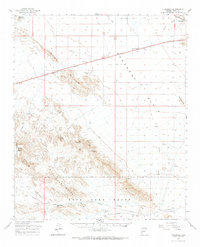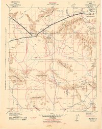
1942 Map of Vicksburg
USGS Topo · Published 1942About this map
The Atchison Topeka and Santa Fe railroad serves as the primary artery through the northwestern reaches of this desert landscape, linking the settlements of Vicksburg, Salome, and Wenden within the McMullen Valley. Military interest in the region during the early 1940s is evident from the notation of a Possible Air Field and Possible Landing Field near the rail line. To the south, the terrain becomes increasingly complex, dominated by the Harquahala Mountains and the Eagle Tail Mountains, where industry is represented by the Socorro Mine and Harquahala Mine.
Find a feature on this map
134 named features on this map. Tap any name to fly to it.
Don’t see what you’re looking for? This feature index may not catch every label — zoom into the map to look around manually.
Map Details
Editions of this 1942 Vicksburg Map
This is the sole edition of this map. No revisions or reprints were ever made.
Historical Maps of Salome Through Time
7 maps found