
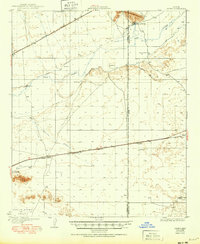
1929 Map of Aztec
USGS Topo · Published 1929About this map
The Gila River defines the lower Sonoran landscape of this 1920s survey, where early irrigation efforts are visible through the Farmers Canal (Abandoned) and various desert water sources like Baragans Well. The settlement of Agua Caliente sits at the foot of the Agua Caliente Mountains, marking a transition from the river valley to the desert uplands. To the south, the Southern Pacific railroad corridor establishes a vital transportation spine, connecting the stops at Aztec and Stanwix. This era of development is characterized by the intersection of rail infrastructure and the remnant traces of dryland agriculture. The map captures a specific moment in the geography of the Yuma Co Maricopa Co Boundary Line, documenting how pioneers navigated the arid terrain between the San Cristobal Valley and the river banks, utilizing landmarks like Sears Point for orientation.
Find a feature on this map
20 named features on this map. Tap any name to fly to it.
Don’t see what you’re looking for? This feature index may not catch every label — zoom into the map to look around manually.
Map Details
Editions of this 1929 Aztec Map
2 editions found
Other maps of this area

1927 · Aguila Mountains
USGS Topo · 1:48,000

1927 · Kim
USGS Topo · 1:62,500

1927 · Hyder
USGS Topo · 1:62,500

1930 · Aguila Mountains
USGS Topo · 1:62,500

1930 · Stoval
USGS Topo · 1:62,500

1930 · Hyder
USGS Topo · 1:62,500

1931 · Kim
USGS Topo · 1:62,500

1942 · Vicksburg
USGS Topo · 1:250,000

1949 · Sentinel
USGS Topo · 1:62,500

1950 · Sentinel
USGS Topo · 1:62,500