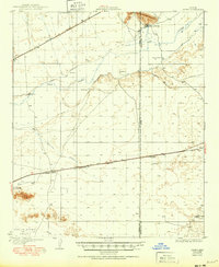
1929 Map of Aztec
USGS Topo · Published 1950About this map
Agua Caliente and the Gila River corridor define this desert landscape during a period of transition for Southwestern irrigation and transport. The map highlights the efforts to manage water in the arid environment, noting the Farmers Canal (Abandoned) and an Abandoned Canal near Sears Point, signifying early agricultural attempts that preceded the more established routes. Movement through the region is centered on the Southern Pacific railroad and U. S. Road 80, which connect small settlements like Aztec and Stanwix. The geography varies from the level San Cristobal Valley in the south to the prominent Agua Caliente Mountains in the north. Local landmarks such as Baragans Well and the Ironwood Ranch provide evidence of early 20th-century ranching and desert habitation, while features like The Lagoon and Sentinel Wash trace the natural drainage of the Gila basin.
Find a feature on this map
24 named features on this map. Tap any name to fly to it.
Don’t see what you’re looking for? This feature index may not catch every label — zoom into the map to look around manually.
Map Details
Editions of this 1929 Aztec Map
2 editions found
Other maps of this area

1927 · Aguila Mountains
USGS Topo · 1:48,000

1927 · Kim
USGS Topo · 1:62,500

1927 · Hyder
USGS Topo · 1:62,500

1929 · Aztec
USGS Topo · 1:62,500

1930 · Aguila Mountains
USGS Topo · 1:62,500

1930 · Stoval
USGS Topo · 1:62,500

1930 · Hyder
USGS Topo · 1:62,500

1931 · Kim
USGS Topo · 1:62,500

1942 · Vicksburg
USGS Topo · 1:250,000

1949 · Sentinel
USGS Topo · 1:62,500