
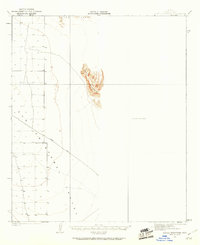
1927 Map of Aguila Mountains
USGS Topo · Published 1927About this map
San Cristobal Valley dominates this 1927 survey, showing the arid expanse of Yuma County before modern irrigation and development transformed the region. The landscape is primarily defined by the wide alluvial basin and the distinct topographic contours of the surrounding mountains. A primary artery through this desert terrain is Yager Road, which strikes diagonally across the valley floor, connecting the scattered township and range markers that organized this portion of the Arizona territory. Mapping efforts were overseen by T. G. Gerdine and conducted by surveyors Bishop Moorhead and C.N. Mortenson, documenting a period when the state was still formalizing its water rights under officials like Frank P. Trott. The map serves as a primary record of the natural desert drainage patterns and the early transportation routes that preceded the modern highway system.
Find a feature on this map
2 named features on this map. Tap any name to fly to it.
Don’t see what you’re looking for? This feature index may not catch every label — zoom into the map to look around manually.
Map Details
Editions of this 1927 Aguila Mountains Map
2 editions found
Other maps of this area

1927 · Kim
USGS Topo · 1:62,500

1929 · Aztec
USGS Topo · 1:62,500

1930 · Aguila Mountains
USGS Topo · 1:62,500

1930 · Stoval
USGS Topo · 1:62,500

1931 · Kim
USGS Topo · 1:62,500

1949 · Sentinel
USGS Topo · 1:62,500

1950 · Sentinel
USGS Topo · 1:62,500

1950 · Stoval
USGS Topo · 1:62,500

1950 · Aztec
USGS Topo · 1:62,500

1953 · Ajo
USGS Topo · 1:250,000