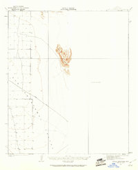
1927 Map of Aguila Mountains
USGS Topo · Published 1960About this map
San Cristobal Valley dominates this arid landscape, showing a region defined more by its natural topography than by human settlement. Surveyed by Bishop Moorhead and C.N. Mortenson, the map captures the stark isolation of the southwestern desert before modern development. The central feature is the Aguila Mountains, rising sharply from the basin floor with intricate contouring that illustrates the complex desert terrain.
Find a feature on this map
5 named features on this map. Tap any name to fly to it.
Don’t see what you’re looking for? This feature index may not catch every label — zoom into the map to look around manually.
Map Details
Editions of this 1927 Aguila Mountains Map
2 editions found
Other maps of this area

1927 · Aguila Mountains
USGS Topo · 1:48,000

1927 · Kim
USGS Topo · 1:62,500

1929 · Aztec
USGS Topo · 1:62,500

1930 · Aguila Mountains
USGS Topo · 1:62,500

1930 · Stoval
USGS Topo · 1:62,500

1931 · Kim
USGS Topo · 1:62,500

1949 · Sentinel
USGS Topo · 1:62,500

1950 · Sentinel
USGS Topo · 1:62,500

1950 · Stoval
USGS Topo · 1:62,500

1950 · Aztec
USGS Topo · 1:62,500