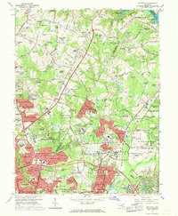
1964 Map of Beltsville
USGS Topo · Published 1969About this map
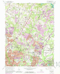
Large federal research facilities and educational institutions dominate the landscape of Prince George's and Montgomery counties during the mid-1960s. The U S Dept of Agriculture Research Center and the U S Naval Ordnance Laboratory occupy massive tracts of land, illustrating the post-war expansion of government infrastructure in the Washington D.C. suburbs. Extensive residential developments like Windham Manor and Valley Stream Estates are shown alongside active industrial zones, evidenced by numerous Gravel Pits and Sand and Gravel Pits concentrated near Muirkirk.
Find a feature on this map
171 named features on this map. Tap any name to fly to it.
Don’t see what you’re looking for? This feature index may not catch every label — zoom into the map to look around manually.
Map Details
Editions of this 1964 Beltsville Map
5 editions found
Other maps of this area

1890 · Mt. Vernon
USGS Topo · 1:125,000

1891 · Mt. Vernon
USGS Topo · 1:125,000

1892 · Laurel
USGS Topo · 1:62,500

1893 · Frederick
USGS Topo · 1:125,000

1894 · Laurel
USGS Topo · 1:62,500

1894 · Frederick
USGS Topo · 1:125,000

1894 · Mt. Vernon
USGS Topo · 1:125,000

1897 · Laurel
USGS Topo · 1:62,500

1897 · Mt. Vernon
USGS Topo · 1:125,000

1899 · Patuxent
USGS Topo · 1:125,000