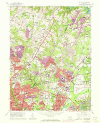
1964 Map of Beltsville
USGS Topo · Published 1972About this map
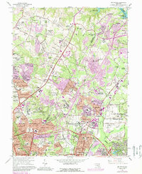
The Patuxent River and the massive Rocky Gorge Reservoir dominate the northern landscape of this region, which was undergoing rapid suburbanization in the late 1960s and early 1970s. This survey illustrates the dense concentration of federal and educational institutional land use, from the U S Naval Ordnance Laboratory in the southwest to the sprawling U S Dept of Agriculture Research Center and the University of Maryland Plant Research Farm. Residential growth is evident in many named subdivisions such as Franklin Knolls, Hillandale Heights, and Windham Manor. Transportation networks like the Capital Beltway and the Baltimore & Ohio RR connect these communities, while numerous gravel pits near the Indian Creek corridor suggest the active extraction industry supporting the era's local construction boom.
Find a feature on this map
186 named features on this map. Tap any name to fly to it.
Don’t see what you’re looking for? This feature index may not catch every label — zoom into the map to look around manually.
Map Details
Editions of this 1964 Beltsville Map
5 editions found
Other maps of this area

1890 · Mt. Vernon
USGS Topo · 1:125,000

1891 · Mt. Vernon
USGS Topo · 1:125,000

1892 · Laurel
USGS Topo · 1:62,500

1893 · Frederick
USGS Topo · 1:125,000

1894 · Laurel
USGS Topo · 1:62,500

1894 · Frederick
USGS Topo · 1:125,000

1894 · Mt. Vernon
USGS Topo · 1:125,000

1897 · Laurel
USGS Topo · 1:62,500

1897 · Mt. Vernon
USGS Topo · 1:125,000

1899 · Patuxent
USGS Topo · 1:125,000