
1932 Map of Bena
USGS Topo · Published 1932About this map
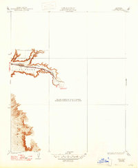
The El Tejon landscape, surveyed in the late 1920s, reveals a rugged terrain defined by deep canyon corridors and transit arteries. This mapping effort by the U.S. Geological Survey under S.N.Stoner focuses on the narrow valley where the Southern Pacific railroad and the Tehachapi Southern Pacific Highway snake through the foothills. The settlement of Bena sits as a critical waypoint at the mouth of these canyons, positioned where the drainage of Walker Basin Creek and Caliente Creek meet the wider valley floor. The map’s structure, which includes large blank areas, emphasizes that the primary interest of this 1932 edition was the documentation of these specific transportation routes and the topography immediately bordering the creek beds. It provides a specialized look at the engineering required to navigate the transition between the San Joaquin Valley and the higher elevations to the east.
Find a feature on this map
8 named features on this map. Tap any name to fly to it.
Don’t see what you’re looking for? This feature index may not catch every label — zoom into the map to look around manually.
Map Details
Editions of this 1932 Bena Map
2 editions found
Other maps of this area

1914 · Caliente
USGS Topo · 1:125,000

1929 · Bena
USGS Topo · 1:31,680

1930 · Bear Mountain
USGS Topo · 1:31,680

1930 · Arvin
USGS Topo · 1:31,680

1931 · Edison
USGS Topo · 1:31,680

1933 · Arvin
USGS Topo · 1:31,680

1933 · Bear Mountain
USGS Topo · 1:31,680

1943 · Cummings Mountain
USGS Topo · 1:62,500

1943 · Breckenridge Mountain
USGS Topo · 1:62,500

1948 · Bakersfield
USGS Topo · 1:250,000