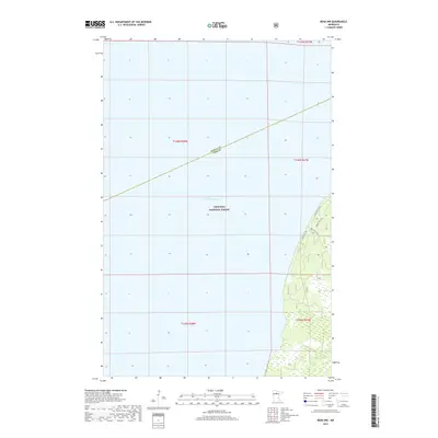
2019 Map of Bena NW
USGS Topo · Published 2019About this map
Lake Winnibigoshish dominates this northern Minnesota landscape, where its vast waters meet the protected timberlands of the Chippewa National Forest. The survey records a critical administrative junction as the boundary between Itasca Co and Cass Co cuts diagonally across the northern reach of the lake. Along the eastern shoreline, a network of service roads and local connectors provides access to the interior, including N High Bank Rd N E and several designated forestry routes like Forest Rte 3001. This area, managed by the U.S. Forest Service, is characterized by its extensive wetland systems and low-lying topography, illustrating the preserved wilderness that defines the headwaters region of the Mississippi River basin.
Find a feature on this map
12 named features on this map. Tap any name to fly to it.
Don’t see what you’re looking for? This feature index may not catch every label — zoom into the map to look around manually.
Map Details
Editions of this 2019 Bena NW Map
This is the sole edition of this map. No revisions or reprints were ever made.
Other maps of this area

1919 · Rosy
USGS Topo · 1:62,500

1919 · Max
USGS Topo · 1:62,500

1954 · Bemidji
USGS Topo · 1:250,000

1957 · Bemidji
USGS Topo · 1:250,000

1958 · Bemidji
USGS Topo · 1:250,000

1971 · Dixon Lake
USGS Topo · 1:24,000

1971 · Nushka Lake
USGS Topo · 1:24,000

1971 · Raven Lake
USGS Topo · 1:24,000

1971 · Bena
USGS Topo · 1:24,000
1971 · Max
USGS Topo · 1:24,000