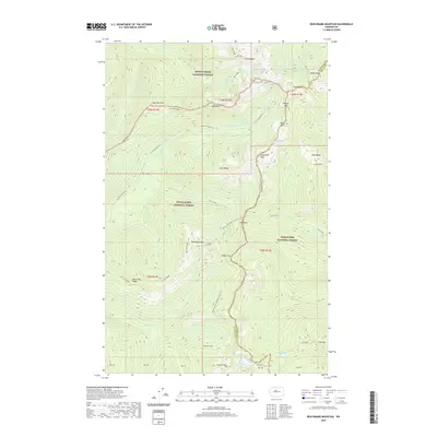
2020 Map of Benchmark Mountain
USGS Topo · Published 2020About this map
Benchmark Mtn and Skykomish Peak dominate this high-altitude landscape where the boundaries of Mount Baker National Forest, Snoqualmie National Forest, and Wenatchee National Forest meet. The geography is defined by the SNOHOMISH CO CHELAN CO line, which follows the crest through a series of significant mountain gaps including Dishpan Gap, Cady Pass, and Wards Pass. The Pacific Crest National Scenic Trail winds along these ridgelines, connecting various alpine water bodies like Pear Lake, Lake Sally Ann, and Blue Lake. This 2020 survey demonstrates the intricate drainage patterns of the region, where the headwaters of the N Fork Skykomish River and N Fork Sauk River originate from snowmelt and glacial runoff near prominent features such as Vimy Ridge and Cady Ridge.
Find a feature on this map
53 named features on this map. Tap any name to fly to it.
Don’t see what you’re looking for? This feature index may not catch every label — zoom into the map to look around manually.
Map Details
Editions of this 2020 Benchmark Mountain Map
This is the sole edition of this map. No revisions or reprints were ever made.
Other maps of this area

1899 · Glacier Peak
USGS Topo · 1:125,000

1901 · Glacier Peak
USGS Topo · 1:125,000

1902 · Skykomish
USGS Topo · 1:125,000

1905 · Skykomish
USGS Topo · 1:125,000

1950 · Glacier Peak
USGS Topo · 1:62,500

1955 · Concrete
USGS Topo · 1:250,000

1957 · Wenatchee
USGS Topo · 1:250,000

1958 · Concrete
USGS Topo · 1:250,000

1962 · Concrete
USGS Topo · 1:250,000

1965 · Captain Point
USGS Topo · 1:24,000