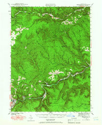
1941 Map of Benezette
USGS Topo · Published 1965About this map
Sinnemahoning Creek and its tributary, Bennett Branch, define the transportation corridors of this Pennsylvania wilderness as documented in 1941. The rail-heavy economy of the era is evident through the path of the Pennsylvania Railroad and the Baltimore and Ohio Railroad, which served industrial outposts like Medix Run and Weedville. Away from the tracks, the landscape transitions into the deep woods of Elk State Forest, where small rural communities like Benezette and Caledonia are anchored by local institutions such as Mt Zion Ch and Rathbun Sch. This survey provides a precise look at the early 20th-century settlement pattern in the PA Wilds, including family landmarks like Gray Cem and the remote Winslow Hill fire tower. The intricate network of drainage, from the aptly named Hellfire Run to Whippoorwill Run, illustrates the complex geography that both challenged and supported the region's timber and transport sectors.
Find a feature on this map
82 named features on this map. Tap any name to fly to it.
Don’t see what you’re looking for? This feature index may not catch every label — zoom into the map to look around manually.
Map Details
Editions of this 1941 Benezette Map
3 editions found
Other maps of this area

1929 · Karthaus
USGS Topo · 1:62,500

1929 · Clearfield
USGS Topo · 1:48,000

1929 · Penfield
USGS Topo · 1:62,500

1932 · Clearfield
USGS Topo · 1:62,500

1932 · Penfield
USGS Topo · 1:62,500

1932 · Karthaus
USGS Topo · 1:62,500

1935 · Mt. Jewett
USGS Topo · 1:48,000

1940 · Mt. Jewett
USGS Topo · 1:62,500

1941 · Benezette
USGS Topo · 1:62,500

1941 · Ridgway
USGS Topo · 1:62,500