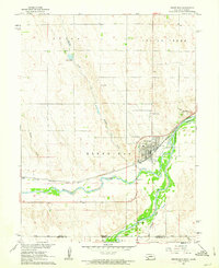
1979 Map of Benkelman
USGS Topo · Published 1979About this map
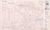
The Republican River valley defines the character of this southwestern Nebraska landscape, where railroads and highways parallel the water to connect a string of prairie settlements in the late 1970s. As the seat of Dundy County, Benkelman serves as the regional anchor, situated at the confluence of river forks near the state lines. The map reveals the critical importance of water management in this arid region, showing the infrastructure of the Swanson Lake and Enders Reservoir systems. These reservoirs and their associated wildlife areas represent a significant mid-century layer of the landscape, overlaid upon an older network of agricultural outposts like Parks, Haigler, and Stratton. To the north and east, the terrain transitions into the more sparsely populated canyon lands near Palisade and Hamlet, illustrating the distinct geographic shifts between the fertile river bottomlands and the surrounding high plains.
Find a feature on this map
12 named features on this map. Tap any name to fly to it.
Don’t see what you’re looking for? This feature index may not catch every label — zoom into the map to look around manually.
Map Details
Editions of this 1979 Benkelman Map
This is the sole edition of this map. No revisions or reprints were ever made.
Historical Maps of Imperial Through Time
6 maps found