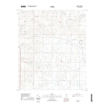
2020 Map of Benton
USGS Topo · Published 2020About this map
Woodlawn and the historic community of Benton anchor this portion of Yazoo County, where the topography is defined by the drainage systems of Walesheba Cr and Little Walesheba Cr. This 2020 landscape reveals a complex network of rural roads that often follow the ridgelines and creek valleys, such as Stubblefield Rd and Graball Freerun Rd. For those tracing local heritage, the map identifies small burial sites including Coopers Cem near the northern boundary and Smith's Cem situated central to the quadrangle. The transition from the more settled eastern edge at Benton to the winding tributaries of Short Cr in the west illustrates the enduring rural character of central Mississippi, where long-established family land divisions and country lanes remain the primary structure of the community.
Find a feature on this map
60 named features on this map. Tap any name to fly to it.
Don’t see what you’re looking for? This feature index may not catch every label — zoom into the map to look around manually.
Map Details
Editions of this 2020 Benton Map
This is the sole edition of this map. No revisions or reprints were ever made.
Other maps of this area

1955 · Jackson
USGS Topo · 1:250,000

1961 · Jackson
USGS Topo · 1:250,000

1961 · Canton
USGS Topo · 1:62,500

1961 · Valley
USGS Topo · 1:62,500

1962 · Jackson
USGS Topo · 1:250,000

1962 · Flora
USGS Topo · 1:62,500
1964 · Zeiglerville
USGS Topo · 1:24,000

1964 · Linwood
USGS Topo · 1:24,000
1966 · Vaughan
USGS Topo · 1:62,500

1984 · Yazoo City
USGS Topo · 1:100,000