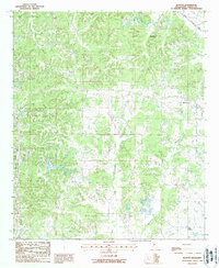
1988 Map of Benton
USGS Topo · Published 1988About this map
Benton sits at the eastern edge of this landscape in Yazoo County, serving as a hub where local roads converge amidst a complex network of waterways. The terrain is defined by the winding paths of Walesheba Creek and Little Walesheba Creek, which drain the central and southern portions of the quadrangle. Northward, the small settlement of Woodlawn and the drainage of Piney Creek illustrate the rural character of the region during the late 1980s. Local industry and recreation are represented by a Gravel Pit and a Golf Course, while the inclusion of a Road Side Park suggests a transition toward modern traveler infrastructure. Small family or community Cem sites are scattered throughout, providing critical touchpoints for genealogists tracing the residents of Mills Crossing and surrounding rural homesteads.
Find a feature on this map
11 named features on this map. Tap any name to fly to it.
Don’t see what you’re looking for? This feature index may not catch every label — zoom into the map to look around manually.
Map Details
Editions of this 1988 Benton Map
This is the sole edition of this map. No revisions or reprints were ever made.
Other maps of this area

1955 · Jackson
USGS Topo · 1:250,000

1961 · Jackson
USGS Topo · 1:250,000

1961 · Canton
USGS Topo · 1:62,500

1961 · Valley
USGS Topo · 1:62,500

1962 · Jackson
USGS Topo · 1:250,000

1962 · Flora
USGS Topo · 1:62,500
1964 · Zeiglerville
USGS Topo · 1:24,000

1964 · Linwood
USGS Topo · 1:24,000
1966 · Vaughan
USGS Topo · 1:62,500

1984 · Yazoo City
USGS Topo · 1:100,000