
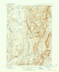
1888 Map of Berlin
USGS Topo · Published 1888About this map
Lebanon Springs Railroad tracks follow the narrow valley floors of eastern Rensselaer County, connecting a string of small dairy and timber settlements during the late nineteenth century. This topography is defined by the steep transition from the Hudson Valley highlands toward the Taconic range at the Massachusetts border. The map illustrates a landscape of clustered hamlets and named hollows, where family-named landmarks like Mc Master Hollow, Barber Hollow, and George Allen Hollow indicate a deeply settled rural economy centered on local agriculture and small-scale water power. Numerous small upland bodies of water, such as Big Bowman Pond and Kendall Pond, feed the drainage of the Poesten Kill and Kinderhook Creek, which were vital for the early industrial development of the region. The survey also captures the precise boundary line between New York and Massachusetts, passing directly over prominent peaks like Berlin Mtn. and Mt. Misery.
Find a feature on this map
78 named features on this map. Tap any name to fly to it.
Don’t see what you’re looking for? This feature index may not catch every label — zoom into the map to look around manually.
Map Details
Editions of this 1888 Berlin Map
2 editions found
Other maps of this area

1886 · Greylock
USGS Topo · 1:62,500

1886 · Becket
USGS Topo · 1:62,500

1888 · Becket
USGS Topo · 1:62,500

1888 · Pittsfield
USGS Topo · 1:62,500

1890 · Pittsfield
USGS Topo · 1:62,500

1890 · Berlin
USGS Topo · 1:62,500

1891 · Greylock
USGS Topo · 1:62,500

1893 · Cohoes
USGS Topo · 1:62,500

1893 · Troy
USGS Topo · 1:62,500

1893 · Becket
USGS Topo · 1:62,500