1975 Map of Berlin
USGS Topo · Published 1981About this map
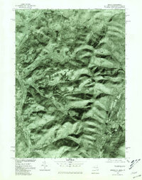
Little Hoosic River carves a central path through the Rensselaer County highlands, anchoring a series of small valley settlements during the mid-1970s. This orthophotograph, prepared from 1975 aerial imagery, reveals the precise distribution of farmland and dense forest surrounding Berlin and Center Berlin. The imagery illustrates how human development clung to the narrow lowlands, with Cherryplain and Petersburg positioned along the primary transit corridor. Beyond the immediate river valley, the terrain rises sharply toward Mount Raimer, while the Southeast Hollow provides a clear view of the deep drainages that defined local land use. Unlike traditional topographic maps, this photographic survey captures the exact texture of the landscape, from individual woodlots to the winding course of the West Branch Green River on the eastern edge of the quadrangle.
Find a feature on this map
8 named features on this map. Tap any name to fly to it.
Don’t see what you’re looking for? This feature index may not catch every label — zoom into the map to look around manually.
Map Details
Editions of this 1975 Berlin Map
This is the sole edition of this map. No revisions or reprints were ever made.
Other maps of this area

1886 · Greylock
USGS Topo · 1:62,500

1888 · Berlin
USGS Topo · 1:62,500

1890 · Berlin
USGS Topo · 1:62,500

1891 · Greylock
USGS Topo · 1:62,500

1893 · Greylock
USGS Topo · 1:62,500

1894 · Berlin
USGS Topo · 1:62,500

1897 · Hoosick
USGS Topo · 1:62,500

1898 · Berlin
USGS Topo · 1:62,500

1898 · Bennington
USGS Topo · 1:62,500

1898 · Greylock
USGS Topo · 1:62,500