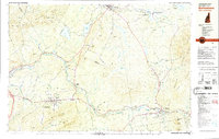
1982 Map of Bethlehem
USGS Topo · Published 1983About this map
The Ammonoosuc River carves a central path through this early 1980s landscape, serving as a corridor for the Boston and Maine Railroad and connecting several small northern New Hampshire settlements. The village of Bethlehem is framed by significant public lands, including Strawberry Hill State Forest and the peaks of Mt Agassiz and Cleveland Mtn. To the north, Whitefield sits near the Johns River and Burns Pond, where the terrain transitions into the Forest Lake State Park and the slopes of Dalton Mountain. This survey records a period when rail infrastructure remained vital to the regional economy, as evidenced by Quebec Junction and Waumbek Junction. Local history is preserved in scattered burial grounds like Maple Street Cem and the Harris-Howland Cem, while the eastern portion of the map is dominated by the wilderness of the White Mountain National Forest.
Find a feature on this map
79 named features on this map. Tap any name to fly to it.
Don’t see what you’re looking for? This feature index may not catch every label — zoom into the map to look around manually.
Map Details
Editions of this 1982 Bethlehem Map
This is the sole edition of this map. No revisions or reprints were ever made.
Other maps of this area

1893 · Mt. Washington
USGS Topo · 1:62,500

1895 · Crawford Notch
USGS Topo · 1:62,500

1896 · Mt. Washington
USGS Topo · 1:62,500

1896 · Crawford Notch
USGS Topo · 1:62,500

1900 · Whitefield
USGS Topo · 1:62,500

1929 · Moosilauke
USGS Topo · 1:62,500

1929 · Franconia
USGS Topo · 1:62,500

1931 · Littleton
USGS Topo · 1:62,500

1932 · Franconia
USGS Topo · 1:62,500

1932 · Littleton
USGS Topo · 1:48,000