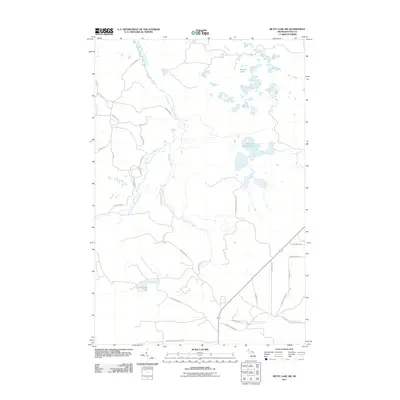
2011 Map of Betsy Lake SW
USGS Topo · Published 2011About this map
The East Branch Two Hearted River winds through this section of the Upper Peninsula, defining a landscape of wetlands and northern forests. This 2011 survey by the U.S. Geological Survey shows a remote network of logging and access roads that crisscross the terrain, including West Fossitt Logging Rd and Old Grade Rd, the latter indicating the region's historical reliance on timber transport. Water is the primary feature of the area, from the clustered Swamp Lakes in the north to the isolated Chesbrough Lake in the southwest. Small tributaries like Widgeon Creek and Savage Creek feed the larger river system, while local routes like Fordney Tower Rd and Spile Dam Rd provide glimpses into the utilitarian naming conventions of the Michigan wilderness.
Find a feature on this map
30 named features on this map. Tap any name to fly to it.
Don’t see what you’re looking for? This feature index may not catch every label — zoom into the map to look around manually.
Map Details
Editions of this 2011 Betsy Lake SW Map
This is the sole edition of this map. No revisions or reprints were ever made.
Other maps of this area

1954 · Sault Sainte Marie
USGS Topo · 1:250,000

1956 · Sault Sainte Marie
USGS Topo · 1:250,000

1957 · Sault Sainte Marie
USGS Topo · 1:250,000

1958 · Sault Sainte Marie
USGS Topo · 1:250,000

1962 · Auger Lake
USGS Topo · 1:24,000

1968 · Muskallonge Lake East
USGS Topo · 1:24,000
1968 · Betsy Lake North
USGS Topo · 1:24,000

1968 · Muskallonge Lake SE
USGS Topo · 1:24,000

1968 · Betsy Lake NW
USGS Topo · 1:24,000

1968 · Betsy Lake SW
USGS Topo · 1:24,000