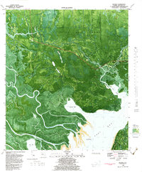
1981 Map of Beverly
USGS Topo · Published 1983About this map
Tates Hell Swamp dominates this coastal landscape where the Apalachicola River and St Marks River converge before entering East Bay. The intricate network of waterways, including the East River and Montgomery Slough, defines the region's geography, punctuated by local landmarks like the East Bay Fire Tower and a Flowing Well. This 1981 orthophotomap provides an aerial perspective on the transition from dense swamp and island terrain, such as Tank Island and Goat Island, to the open bay waters.
Find a feature on this map
41 named features on this map. Tap any name to fly to it.
Don’t see what you’re looking for? This feature index may not catch every label — zoom into the map to look around manually.
Map Details
Editions of this 1981 Beverly Map
This is the sole edition of this map. No revisions or reprints were ever made.
Other maps of this area

1943 · West Pass
USGS Topo · 1:31,680

1943 · Apalachicola
USGS Topo · 1:31,680

1943 · Jackson River
USGS Topo · 1:24,000

1944 · Green Point
USGS Topo · 1:31,680

1944 · Apalachicola
USGS Topo · 1:24,000

1944 · Forbes Island
USGS Topo · 1:24,000

1945 · Forbes Island
USGS Topo · 1:31,680

1945 · Tates Hell Swamp
USGS Topo · 1:31,680

1945 · Beverly
USGS Topo · 1:31,680

1945 · Jackson River
USGS Topo · 1:31,680