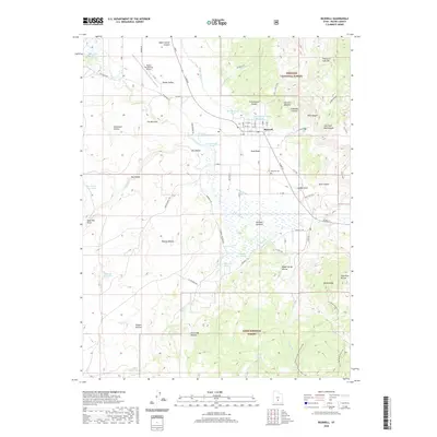
2020 Map of Bicknell
USGS Topo · Published 2020About this map
Bicknell lies at the heart of Rabbit Valley, where the waters of the Fremont River create the marshy Bicknell Bottoms. This high-altitude landscape is defined by the transition from the irrigated valley floor to the massive uplift of Thousand Lake Mtn and the dense timber of Fishlake National Forest and Dixie National Forest. The map documents a complex water management system essential for agriculture in this arid region, featuring the High Line Ditch, Spring Ditch, and various collection points like the East Bicknell Sand Wash Pond. Topographical landmarks such as The Narrows and Saddle Knoll frame the valley, while local history is anchored by the Bicknell Cem and the Wayne Wonderland Airport, which serves as a gateway to this isolated portion of Wayne County.
Find a feature on this map
81 named features on this map. Tap any name to fly to it.
Don’t see what you’re looking for? This feature index may not catch every label — zoom into the map to look around manually.
Map Details
Editions of this 2020 Bicknell Map
This is the sole edition of this map. No revisions or reprints were ever made.
Other maps of this area

1885 · Fish Lake
USGS Topo · 1:250,000

1896 · Fish Lake
USGS Topo · 1:250,000

1952 · Notom 2 NW
USGS Topo · 1:24,000

1952 · Loa 1 SE
USGS Topo · 1:24,000

1952 · Notom 3 NW
USGS Topo · 1:24,000

1952 · Notom 2 SW
USGS Topo · 1:24,000

1952 · Grover
USGS Topo · 1:62,500

1952 · Torrey
USGS Topo · 1:62,500

1952 · Loa 1 NE
USGS Topo · 1:24,000

1953 · Loa 4 NE
USGS Topo · 1:24,000