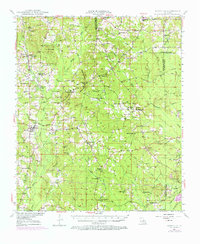
1947 Map of Bienville
USGS Topo · Published 1973About this map
Driskill Mountain rises as a prominent landmark in this North Louisiana landscape, where the rural topography is defined by the headwaters of the Dugdemona River and various creek systems. During the mid-twentieth century, the area around Bienville and Bryceland remained a patchwork of small communities and family-named features. The map illustrates a religious and educational network through numerous country institutions like Mt Temple Ch, Mt Olive Ch, and the St Paul School. Cultural continuity is visible in the placement of the Pruitt Cem and Taylor Cem. Industrial activity is marked by the presence of an Old Railroad grade and scattered Gas Wells, indicating the transition from traditional timber or agricultural interests toward petroleum extraction in the Lincoln Parish and Bienville Parish borderlands.
Find a feature on this map
75 named features on this map. Tap any name to fly to it.
Don’t see what you’re looking for? This feature index may not catch every label — zoom into the map to look around manually.
Map Details
Editions of this 1947 Bienville Map
2 editions found
Other maps of this area

1947 · Goldonna
USGS Topo · 1:62,500

1947 · Ashland
USGS Topo · 1:62,500

1947 · Bienville
USGS Topo · 1:62,500

1948 · Jamestown
USGS Topo · 1:62,500

1949 · Jamestown
USGS Topo · 1:62,500

1949 · Bienville
USGS Topo · 1:62,500

1949 · Jonesboro
USGS Topo · 1:62,500

1949 · Gibsland
USGS Topo · 1:62,500

1950 · Jonesboro
USGS Topo · 1:62,500

1950 · Gibsland
USGS Topo · 1:62,500