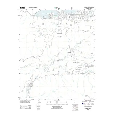
2012 Map of Big Bear Lake
USGS Topo · Published 2012About this map
Big Bear Lake and its surrounding mountain communities are captured here during a period of established recreation and alpine development. The northern shoreline is defined by numerous landings and marinas, including Gibralter Landing and Knot Landing, highlighting the area's role as a major high-altitude destination. In the southern half of the quadrangle, the landscape shifts toward the more secluded San Bernardino Mountains, where numerous organized retreats like Camp Radford and Camp Tahquitz are situated along the Santa Ana River and its tributaries. The map documents the intricate road networks serving both the lakeside residences and the seasonal resorts. From the residential streets of Boulder Bay to the recreation hubs at Snow Summit Ski Area and Barton Flats Campground, this survey illustrates the balance between dense settlement and protected forest land in Southern California.
Find a feature on this map
158 named features on this map. Tap any name to fly to it.
Don’t see what you’re looking for? This feature index may not catch every label — zoom into the map to look around manually.
Map Details
Editions of this 2012 Big Bear Lake Map
This is the sole edition of this map. No revisions or reprints were ever made.
Other maps of this area

1899 · Redlands
USGS Topo · 1:62,500

1901 · Southern California Sheet No. 1
USGS Topo · 1:250,000

1901 · Redlands
USGS Topo · 1:62,500

1902 · Deep Creek
USGS Topo · 1:62,500

1902 · San Gorgonio
USGS Topo · 1:125,000

1904 · Southern California Sheet No. 1
USGS Topo · 1:250,000

1947 · Lucerne Valley
USGS Topo · 1:62,500

1949 · Lucerne Valley
USGS Topo · 1:62,500

1953 · San Bernardino
USGS Topo · 1:250,000
1953 · Keller Peak
USGS Topo · 1:24,000