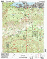
1996 Map of Big Bear Lake
USGS Topo · Published 1999About this map
Big Bear Lake and its surrounding mountain communities define this high-altitude landscape within the San Bernardino National Forest. The map documents a dense network of institutional and recreational camps such as Camp Arbolado, Camp Tahquitz, and Camp O-ongo Rancho, illustrating the area's long-standing role as a mountain retreat. While the northern shore shows concentrated development around Big Bear Lake and its schools, the terrain drops south toward the Santa Ana River and the expansive San Gorgonio Wilderness. Local history and genealogy researchers can locate family-named landmarks like Merriman Meadows and Johns Meadow, alongside established settlements at Seven Oaks Resort and Angelus Oaks. This 1990s revision provides an exceptionally detailed look at the interface between wilderness preservation and the established resort infrastructure that grew around the Boulder Bay area and the high peaks of the San Bernardino Mountain range.
Find a feature on this map
96 named features on this map. Tap any name to fly to it.
Don’t see what you’re looking for? This feature index may not catch every label — zoom into the map to look around manually.
Map Details
Editions of this 1996 Big Bear Lake Map
This is the sole edition of this map. No revisions or reprints were ever made.
Other maps of this area

1899 · Redlands
USGS Topo · 1:62,500

1901 · Southern California Sheet No. 1
USGS Topo · 1:250,000

1901 · Redlands
USGS Topo · 1:62,500

1902 · Deep Creek
USGS Topo · 1:62,500

1902 · San Gorgonio
USGS Topo · 1:125,000

1904 · Southern California Sheet No. 1
USGS Topo · 1:250,000

1947 · Lucerne Valley
USGS Topo · 1:62,500

1949 · Lucerne Valley
USGS Topo · 1:62,500

1953 · San Bernardino
USGS Topo · 1:250,000
1953 · Keller Peak
USGS Topo · 1:24,000